
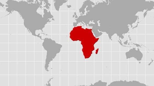
For centuries, world maps have been designed using the Mercator projection, a cartographic technique that distorts the size of continents, particularly making Africa appear significantly smaller than it actually is. When Africa is represented at its true size, it becomes evident that the continent is not just larger than commonly depicted, but it is, in fact, the largest and most diverse region on Earth. This revelation has profound implications for educational systems, global perspectives, and the way we understand our world.
The Distortion of Africa on Traditional Maps
The Mercator projection, developed in 1569 by Gerardus Mercator, was designed for navigation purposes, not for accurately representing the size of continents. While it preserves angles and shapes, it exaggerates the size of areas farther from the equator, such as Europe and North America, while minimizing the size of equatorial regions, most notably Africa.
Key Distortions
1. Size Misrepresentation: Africa is approximately 30.4 million square kilometers, which is about 660 times the size of the United Kingdom. However, on many traditional maps, Africa appears to be about the same size as Greenland, which is actually only about 2.2 million square kilometers.
2. Geographical Misconceptions: The distortion leads to a skewed understanding of the relative sizes of countries and continents. For example, the United States, which is about 9.8 million square kilometers, appears larger than Africa on many maps, despite being less than a third of its size.
3. Cultural and Historical Impact: The misrepresentation of Africa’s size contributes to a broader cultural and historical narrative that often underestimates the continent’s significance and diversity.
Implications for Educational Systems
1. Rewriting Geography Curricula
Educational systems worldwide need to update their geography curricula to include accurate representations of Africa. This involves:
– Incorporating True-Size Maps: Schools should integrate maps that accurately depict the size of Africa and other continents. The “True Size” map, which uses the Peters projection, is a good alternative as it minimizes distortion and provides a more accurate representation.
– Interactive Learning Tools: Utilizing digital tools and interactive maps can help students visualize the true size of Africa and understand the implications of cartographic distortions.
2. Enhancing Historical and Cultural Education
Understanding the true size of Africa can also enhance the teaching of history and cultural studies:
– Colonialism and Trade: Accurate representations can help students better understand the scale and impact of colonialism, trade routes, and historical events.
– Cultural Diversity: Africa’s true size underscores its vast cultural diversity, with over 1,500 languages and a rich tapestry of traditions, histories, and contributions to global civilization.
3. Promoting Critical Thinking
Educators should encourage students to question and critically analyze the information presented in maps and other educational materials. This includes:
– Discussing Cartographic Bias: Engaging students in discussions about the biases inherent in different map projections and the historical context behind them.
– Encouraging Research: Assigning projects that require students to research and compare different map projections, fostering a deeper understanding of geography and cartography.
Impact on Global Perspectives
1. Redefining Global Power Dynamics
The true size of Africa challenges the Eurocentric view of the world and promotes a more balanced understanding of global power dynamics. Recognizing Africa’s size and resources can lead to:
– Economic Recognition: Africa’s vast natural resources, diverse economies, and growing markets can be better appreciated and integrated into global economic discussions.
– Political Representation: Accurate representation can contribute to more equitable political and diplomatic engagements, recognizing Africa’s influence and leadership in international affairs.
2. Fostering Global Awareness and Empathy
Understanding the true size of Africa can foster greater global awareness and empathy:
– Humanitarian Efforts: Accurate representations can help highlight the scale of humanitarian challenges and opportunities in Africa, leading to more informed and effective global responses.
– Cultural Exchange: Recognizing Africa’s size and diversity can promote cultural exchange and mutual understanding, breaking down stereotypes and fostering global solidarity.
3. Inspiring Future Generations
The true size of Africa serves as a powerful symbol of the continent’s potential and the need for accurate and inclusive education:
– Role Models and Achievements: Highlighting Africa’s achievements and contributions can inspire future generations to aspire to greatness and recognize their own potential.
– Global Citizenship: Educating students about the true size of Africa and its global significance can foster a sense of global citizenship, encouraging them to engage with and contribute to a more equitable and just world.
Conclusion
The true size of Africa is a powerful reminder of the importance of accurate and inclusive education. By updating curricula, promoting critical thinking, and fostering global awareness, we can challenge long-standing misconceptions and promote a more balanced and equitable understanding of our world. Recognizing Africa’s true size is not just about correcting a cartographic error; it is about redefining our global perspectives and inspiring future generations to embrace a more inclusive and just world.
Leave a Reply